
[ad_1]
Forecasters’ fears are coming to pass with a second major wave of rain bearing down on the country’s east, exacerbating the already dire conditions.
Meteorologists have said there are “grave concerns” for communities, particularly along the NSW north coast as a “conveyor belt of heavy rain” heads east topping up already flooded rivers.
A metre of rain has fallen across parts of the NSW mid north coast over the last few days. Red Oak and Comboyne received almost 900mm in the last week and as much as 200mm more could fall over the coming days.
RELATED: Follow our blog for live flood updates
TWO RAIN SYSTEMS SET TO COLLIDE
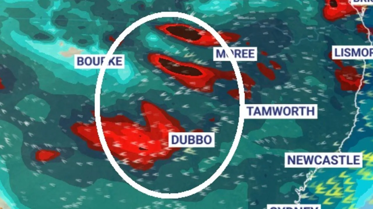
This new weather event is currently barrelling through Central Australia. It should head into western NSW and Queensland during Monday. In some of these arid regions, where rainfall is far lower than the coast, it could bring an entire season’s worth of rain in just a couple of days.
The fresh burst of rain should then hit the NSW coast on Tuesday morning. That could see Byron Bay, already underwater, drenched with another 100mm or more of rain.
“These two system will collide on Monday night and into Tuesday and its likely we will see a significant multistate rain band,” Bureau of Meteorology’s (BOM) Jonathan How said.
A severe weather warning image from the BOM (below) vividly illustrates the two separate systems over NSW. One warning area covers the coast, where the trough has lingered while a huge lick of moisture coming in from the west is the new band.
RELATED: Full list of road and rail closures due to rain and floods in NSW
RELATED: Dam spilling one Sydney Harbour a day
RAIN BLAST’S ‘LAST HURRAH’
The new system should help expand the rain beyond NSW.
“Southeast Queensland joined the party yesterday with heavy rain and thunderstorm activity late yesterday and then continued overnight, and through today we’re still seeing areas of rain running through that region,” Sky News Weather meteorologist Rob Sharpe said on Monday morning.
Brisbane could see between 100mm and 150mm of rain between now and Wednesday; while rivers in the Gold Coast have burst their banks.
Some of that moisture could hit Victoria and Tasmania as well as large swathes of the outback.
“Heavy falls are threatening multiple regions; we’re going to see further flooding in multiple other areas today due to this weather event,” Mr Sharpe said.
He added the rainfall was likely to intensify on Tuesday before it finally heads off into the Tasman.
“For east coast areas we’re looking at one final hurrah, on Tuesday, in the afternoon for most areas.”
For Sydney, another 40-70mm of rain could fall today and then up to a further 80mm on Tuesday before sunny skies on Wednesday.
In Port Macquarie, heavily affected by the current event, up to 90mm could rain down on Monday and then 70mm on Tuesday.
Extraordinary conditions are forecast for Bourke. The inland NSW town, some 800km from the coast, can usually expect just 16mm of rain in March.
But as that new weather band moves through, it could see at least double that amount of rain on Monday, possible as much as 60mm. A further 35mm is set to descend on Tuesday.
That could mean the entirety of Bourke’s autumn’s rainfall might be surpassed in less than two days.
The rain gauge in Brisbane could almost reach 100mm today followed by a top-up of between 30-45mm tomorrow and a further 25mm on Wednesday.
Canberra can expect up to 20mm of rain today followed by very heavy downpours on Tuesday delivering up to 70mm of precipitation before drier conditions on Wednesday.
RELATED: Most shocking photos from NSW floods
RAIN HEADING INTO VICTORIA, TAS
“The heavy rain will run down into parts of Victoria and Tasmania as a small low pressure system forms,” Mr Sharpe said.
Melbourne is looking at light showers today and then up to 10mm on Tuesday with further rain as the week progress.
The rain is set to arrive in Hobart on Tuesday but Wednesday will be the wettest day with 10-25mm falling and another 10mm on Thursday.
A separate system could bring a touch of rain to Adelaide from midweek onwards. But it will be mostly dry in the South Australian capital with temperatures in the mid-twenties.
Soggy in Darwin will have afternoon thunderstorms and rain totals of 10-15mm each day this week. Alice Springs could see storms on Monday and Tuesday with as much as 30mm in the gauge.
No rain in Perth where it will remain sunny this week. But the mercury should dip from its scorching highs last week to settle in the mid-to-high twenties.
[ad_2]
Source link